|
 |  Overview 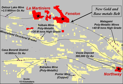
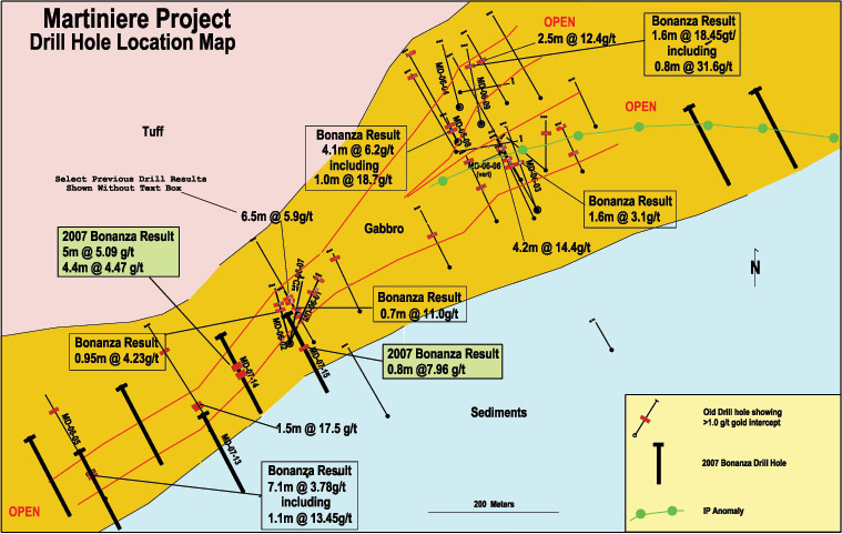
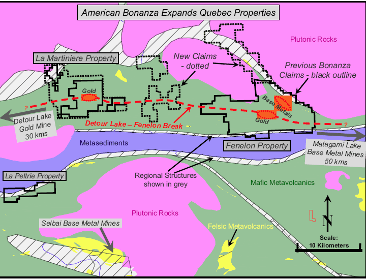
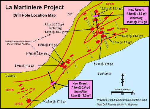 Previous Work In 1997, following a program of geophysical surveying, Cyprus Canada Inc drilled two diamond drill holes on the property totalling 310.5 metres. The second hole, MD97-02, intersected massive to semi-massive pyrite mineralization over 13 metres with tourmaline and strong carbonate, sericite, silicification and fuchsite alteration throughout the hole. This resulted in an additional six holes, which intersected three separate auriferous horizons. International Taurus Resoures Inc acquired the property in 1998 and, in 1999 and 2000, completed 21 drill holes, totalling 3,807 metres (Taurus recently merged with American Bonanza Gold Mining Corp to form American Bonanza Gold Corp). This work further indicated the widespread nature of gold mineralization and suggests that the higher-grade mineralization is contained in veins and shoots, similar to the occurrence at the high-grade Fenelon Gold Project. The best gold assay from this drilling is shown in the Map Gallery on Section 16E and returned 14.4 grams per tonne gold over 4.2 metres. Geology The Martiniere project is located in the northern-most Harricana -Turgeon Belt region of the northern edge of the Abitibi Greenstone Belt, which includes the Matagami, Joutel, Brouillan and Casa Berardi mining districts. The region is underlain by sedimentary and mafic to felsic volcanic rocks with coeval intrusives, all of Archean age. The major structural feature in the region is the east-west trending Detour Lake Break. These rocks and structure are identical to the lithologies in the southern half of the Abitibi Belt, which host mines that produced over 150 million ounces of gold and 500 million tonnes of ore. The property is entirely covered by glacial overburden. Drilling to date in this area shows it to be largely underlain by sedimentary rocks, consisting of argillite, siltstone, graphitic argillite and related massive pyrite mineralization. These are intercalated with zones of strongly altered carbonatized and sericitized volcanic mafic flows and intermediate tuffaceous rocks. Only scattered areas of bedrock are exposed in small ranges of hills and along major rivers. What is known of the geology is almost entirely derived from the interpretation of geophysical surveys and drill hole data. The discovery of all deposits in the area, including Detour Lake, Golden Pond, Estrades, Joutel, Selbaie and Fenelon, were made through use of geophysical methods. Potential A significant new quartz-carbonate vein system has been intersected on the Martiniere property. Several Taurus holes drilled in 1999 and 2000 expand the original Cyprus discovery to over a 400-metre strike length. Drilling to date indicates a significant economic potential for this system. Additional drilling is required to determine the controls and distribution of mineralization and to further explore the deposit. There is also considerable potential for the discovery of additional systems of gold mineralization on the remainder of the large Martiniere property. Geophysical work indicates numerous anomalies similar to the recent discovery and intercepts of strongly anomalous gold in holes peripheral to the discovery zone further indicate that a robust gold system is present. Proposed Program The results to date justify a significant staged program of geophysical surveying and drilling to further evaluate the gold system at Martiniere. The recommended program includes 10 line-kilometres of IP-resistivity survey and 2000 metres of diamond drilling. The total cost of this program is estimated to be CDN$200,000. Map Gallery
|
 |
©2006 American Bonanza Gold Corporation All Rights Reserved. | Disclaimer |